Weer en sneeuw
Weer in Zuid-Tirool
Laatste update: 30.07.2026, 11:00
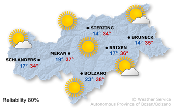
Het weer vandaag
High air pressure and dry air masses determine the weather.
The afternoon will see plenty of sunshine. Only a few, mostly cumulus clouds will form, and the likelihood of thunderstorms will remain low.
It’s going to be very hot, with temperatures reaching 34° in Sterzing and 38° in Bozen.
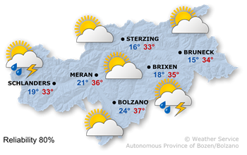
Het weer morgen
With the upper-level flow the atmospheric stratification will becoming less stable.
This morning will once again be cloudless with plenty of sunshine. As the day progresses, more cumulus clouds will form, and localised heat-induced thunderstorms are expected during the afternoon and evening.
Very hot again, with maximum temperatures of 33° in the Wipptal valley and 37° in the Bolzano area.
Verdere ontwikkeling

36°/13°
Zaterdag, 01.08

35°/14°
Zondag, 02.08
35°/13°
Maandag, 03.08
34°/13°
Dinsdag, 04.08
Not much will change on Saturday. The sun will shine widely during the first half of the day. In the afternoon, large cumulus clouds will develop, followed by a few heat-induced thunderstorms.
Sunday will bring midsummer conditions with sunshine and localised thunderstorms in the afternoon.
On Monday morning, there will be glorious sunshine, but a few thunderstorms will develop again in the afternoon.
Tuesday will also bring plenty of sunshine in the morning, after which thunderstorms are expected once more.
Bergweer vandaag
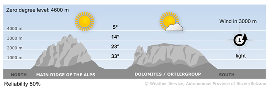
Lots of sunshine, very warm
The morning will be mostly cloudless, with just a few patches of low stratus clouds. In the afternoon, mostly small cumulus clouds will develop, and the risk of thunderstorms will remain low.
Wind op grote hoogte
1 - zwakke wind
5-15 km/u
2 - matige wind
16-30 km/u
3 - sterke wind
31-60 km/u
Bergweer morgen
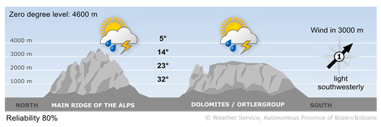
Very good mountain weather this morning
The morning will be characterised by excellent visibility and largely cloudless conditions. In the afternoon cumulus clouds and the risk of thunderstorms will gradually increase in the afternoon.
Wind op grote hoogte
1 - zwakke wind
5-15 km/u
2 - matige wind
16-30 km/u
3 - sterke wind
31-60 km/u